

On September 31, 2025, a devastating earthquake hit the central Philippines, killing at least 74 people, injuring at least 150 more, and leaving countless more homeless in the Cebu province. Less than two weeks later, two more earthquakes hit the Philippines just seven hours apart. Here, btw takes a closer look at the causes and effects of earthquakes on the region.
A Deadly Quake
People who live in the Philippines are not unused to earthquakes. In fact, the country experiences more than 800 earthquakes per year. But the September 31 quake was significant because it was the deadliest quake in more than a decade. The earthquake registered a 6.9 magnitude on the Richter scale and hit around 10 pm local time, catching people off guard. It also triggered landslides in some mountain villages and fires in the cities. Churches, schools, and sports complexes collapsed, and hospitals have been overwhelmed with injured people.
(Earthquakes are measured and compared to one another using the Richter scale. This numerical scale measures the back-and-forth movement of seismic waves. This helps determine the amount of actual movement that the land experiences during a quake. It is also important to remember that this scale is logarithmic. That means that there is not an equal amount of change from one unit of measurement to another. Instead, the destructive possibility of an earthquake rises quickly as you increase the number on the Richter scale.)
At the same time, there was also a minor eruption from the Taal volcano, just south of central Manila. While the plume of smoke could be seen from far off, the threat level remained low.
Twin Quakes
On October 10, less than two weeks later, two more earthquakes stuck off the shore of the southern Philippines. The first earthquake registered a magnitude of 7.4, the second with a 6.8. The second earthquake hit just seven hours after the first. It triggered a tsunami warning that led to evacuation of coastal towns. (The tsunami warning was later lifted.) At least seven people were killed, and many structures damaged, including schools and a hospital.
The Ring of Fire
Why are earthquakes so common in the Philippines? It helps to understand the concept of tectonic plates. Tectonic plates are huge slabs of the earth’s crust that float on the earth’s mantle (hot molten rock beneath the Earth’s surface, sometimes called magma). When those plates bump or push against each other, it results in volcanoes, earthquakes, and other geological instability.
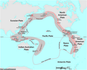
The Ring of Fire is a 25,000-mile-long semicircle of active fault lines around the Pacific Ocean. These fault lines mark places where tectonic plates push up against each other. In fact, more than half of the world’s volcanoes occur in this area. That is because the magma pushes up through the cracks in the tectonic plates. Earthquakes are caused when two plates rub against each other and create friction. Energy builds up, and when it is released, an earthquake happens.
Fifteen countries lie along the Ring of Fire, including Chile, Japan, Russia, Papua New Guinea, Indonesia, the U.S. west coast, and the Soloman Islands–as well as the Philippines. While it’s more likely that earthquakes will happen in these areas, scientists can’t yet predict when they will occur, or how large they will be when they do.